The Boundaries of Northern Ireland: 1921 – 2020
1921 – 1979
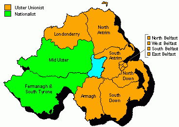
The six counties of Northern Ireland (created after the creation of the Irish Free State in 1921) have been returning MP’s to Westminster centuries, but it is only since 1950 when the concept of one elector, one vote was established with the abolition of the university seats that Northern Irelan’s MP’s really started to count. It is quite amazing to think that for twenty nine years (with the UK wide boundary changes in 1955 and February 1974) the same boundaries were in place which might so some way to explain why at the 1979 general election, the Antrim South constituency had an electorate of 126,493 (which should be compared with the biggest electorate in mainland Britain which could be found at Bromsgrove which had an electorate of 104,375).
The constituencies in Northern Ireland for those elections were the four seats in Belfast (East, North, South and West), Antrim (North and South), Down (North and South), Armagh, Londonderry, Mid Ulster and finally Fermanagh and South Tyrone and over those twenty nine years whilst the constituencies didn’t change shape, the politics most certainly did.
In 1950, Northern Ireland was a Unionist stronghold with the party polling 63% of the vote and winning ten seats, the two remaining seats (Fermanagh and South Tyrone, Ulster Mid) being won by the Irish Nationalists but in the popular vote they were way behind polling just 12% of the vote. The next most popular party to the Unionists was Labour, yes, in the early days Labour contested Northern Ireland and in 1950 polled 21% of the vote with Sinn Fein bringing up the rear with just 4%. Fast forward to 1979 and it’s clear what an effect the Troubles had had on the politics of the province.
Instead of just one Unionist bloc, there were five types of Unionist. You had the Democratic Unionist and Loyalist party (7%), the Democratic Unionist Party (4%), the Official Ulster Unionist Party (15%), the Official Unionists (21%) and the Unionist Party of Northern Ireland (1%). But the non Unionist side had also fractured with the Irish Independence Party (3%), the Republican Clubs (2%), the Social Democratic and Labour Party (18%) and as a result instead of the Unionists winning ten seats as they had done in 1950, the Democratic Unionists won three seats (helped by the Loyalists), the Official Unionists won five, the SDLP won one seat, the Ulster Unionists won one seat and the United Ulster Unionists also won a seat.
1983 – 1992
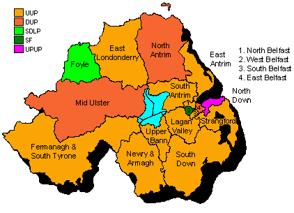
After the collapse of self government in Northern Ireland in 1982, it was decided that more Northern Ireland MP’s should go to Westminster and so for the first time new constituencies were created (and with that decision new names entered the Parliamentary Constituency lexicon, say “Hello” to Upper Bann and Lagan Valley) but there weren’t just new constituencies, some got split. The mighty Londonderry in the north got split to form Londonderry East and Foyle, Antrim North and Antrim South were put on a diet and a new Antrim East was born, and Down North became a mere shadow of it’s former self in order to make room for a new Strangford constituency.
Added to those changes were the political changes as well, the Democratic Unionists managed to gather all of their pieces into one, as did the Ulster Unionists and Sinn Fein appeared on the scene again and managed to win Belfast West thanks to Gerry Fitt, the former SDLP MP for the seat splitting the nationalist vote by standing as an Independent Socialist candidate. By 1992, however the Democratic Unionists were starting to fade with the SDLP being seen as the main nationalist challenger having picked up Newry and Armagh, Down South and then Belfast West from Sinn Fein, by which time Northern Ireland came into line with the rest of the United Kingdom and a new set of boundaries for, what by 1995 was becoming clearly apparent, a new government.
1997 – 2010
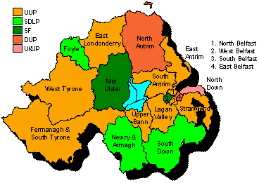
At the 1997 boundary changes, we got a new seat in form of Tyrone West (which some American political commentators thought was an ode de homage to the American actor Tyrone Powers) but that wasn’t the only change in Northern Ireland. As well as splitting Mid Ulster to create the new Tryone West seat, Londonderry East and Foyle were put on diets which Foyle halving in size. The changes seemed to help everyone as the Ulster Unionists won the new West Tyrone, Sinn Fein gained the reduced Mid Ulster, and thanks to a slight rejigging of the Belfast seats, Belfast West as well.
As the 2001 and 2005 parliaments were elected the so called “Greening of the West” occurred as Sinn Fein took first Tyrone West and Fermanagh in 2001 and then Newry in 2005 helped in part by the collapse of the Ulster Unionists from 34% in 1992 to 20% in 2005 as the Democratic Unionists became the main force of Unionism (14% to 32%) but the times they were a changing and yet for Northern Ireland the new boundaries appeared to be nothing more than a tidying up operation.
2010 – present
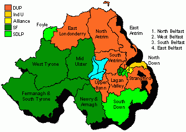
The boundary changes in 2010, could be compared to visiting a plastic surgeon. “Hello there, yes, I wonder if you can help me? I’d like Foyle to be halved in size again, Antrim East stretched up the coast a little, could you add a bit to Lagan Valley and Strangford and I’d like Belfast East stretched a little?” The changes were merely cosmetic, but boy, did they have an impact in 2010.
The new Belfast East rocked the political world by electing Alliance’s first ever Westminster MP, Belfast South elected the SDLP (despite the boundary changes helping the DUP), and in North Down Lady Hermon became the first Independent MP to be elected as a full blown Independent (not an offshoot of any party) since the 1950’s. And at the last election, after an absence of nearly ten years, the Ulster Unionists gained two seats to sit on the Westminster benches, but now for the first time since the birth of modern politics, Northern Ireland faces a challenge. It is going to lose a seat (17 constituencies) and come to terms with the fact that of the 18 constituencies only four are big enough to stay as they are.
2020
At midnight tonight, the Boundary Commission for Northern Ireland will become the first Commission to release their initial report into how Northern Ireland’s 17 constituencies will be created and by Wednesday I will post how those 17 might have gone if they had been in place in 2015. Will Sinn Fein be able to reclaim Fermanagh? Will the SDLP’s hold on Foyle increase or will it become a SDLP / Sinn Fein marginal? And what of North Down, will Lady Hermon have a seat to call her own or will the DUP sense the chance to make it a true Unionist seat?
Harry Hayfield
The following calculations are all my own work and are based on the initial proposals announced at midnight this morning
Antrim East: DUP safe, Antrim North: DUP safe, Antrim West: DUP safe, Belfast East: DUP / Alliance marginal (DUP safe if Unionist pact in place), Belfast North West: SF / DUP marginal (unlikely to change if Unionist pact in place), Belfast South West: SF safe, Dalriada: DUP safe, Down North: Ind safe, Down South: SDLP safe, Down West: DUP safe, Fermanagh and South Tyrone: SF / UUP marginal (potential to change hands if Unionist pact in place), Foyle: SDLP safe, Glenshane: SF marginal (Unionist safe if Unionist pact in place), Newry and Armagh: SF safe, Strangford: DUP safe, Tyrone North: SF safe, Upper Bann and Blackwater: SF marginal (Unionist safe if Unionist pact in place)